 The way to Bhutan
(Information and details courtesy, Tourism Council of Bhutan (TCB)
Until 1964 The Kingdom of Bhutan was accessible only by foot through the
high passes of Tibet. The construction of a road from Phuntsholing on
the Indian border to Thimphu and Paro made travel by car and bus
possible. In the 1980's an international airport was constructed in
Paro, 55 km from the capital of Bhutan, Thimphu. Travel by Air
Today, Bhutan's national air carrier, Druk Air, operates
several flights per week from Paro to Bangkok, Delhi, Kolkata, Dhaka and
Kathmandu. The modern Airbus A-319 jets carry passengers through one of
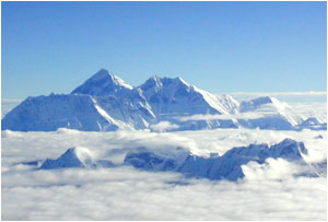
the most spectacular flight paths in the world. A particular highlight
is the stretch between Kathmandu and Bhutan, where one passes 4 of the 5
highest mountains in the world. Weather permitting, passengers will be
treated to intimate views of Mt. Everest, Lhotse, Makalu und
Kangchenjunga. Landing in the Paro Valley, surrounded by 4000 meter high
mountains stretching across the west of Bhutan, means a visual landing
is the order of the day.  For current flight schedules, click
 DRUK AIR Flights are
booked through Tour Operators who also arrange visas.
Travel by
Land
The town of Phuntsholing in south-western Bhutan is currently the only
land border access open for international tourists. Phuntsholing lies
approximately 170 km east of the Indian national airport Bagdogra,
nearby historic Darjeeling. From here begins a mountain journey of
almost unbelievable beauty. The road leads from the northern Indian tea
plantations through endless turns, hair-pin bends and daring stretches
carved into the mountain rock via Chhuka to Thimphu. The travel time for
the 175 km stretch can be more than 7 hours.
A combination of overland and air travel is also possible. All overland
travel requires an Indian visa.
With the exception of the Gasa district, all major towns in the 20
districts of Bhutan are accessible by road. Despite high mountains,
steep slopes, and the deepest of valleys, Bhutan has a relatively well
developed network of roads. That said, rarely will one find a length of
either straight or flat road. In some stretches one can encounter 6 to 7
bends per kilometre! Steep ascents and descents are characteristic of
road travel in Bhutan and this can make travel much slower than one may
be used to. Average speeds for road travel rarely exceed 30 km/h, with
tourist buses making even slower progress. One is however handsomely
rewarded for the long and sometimes tiring car journey, by the
spectacular views of towering mountains, lush green jungle, ancient
villages and majestic monasteries.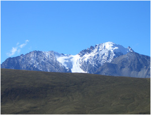 The majority of roads are sealed but can still be
bumpy and are almost always single lane. Bhutan's drivers know their
land well and are cautious and careful drivers. The density of traffic
is normally very low. The Royal Government of Bhutan sets minimum
selling prices for packages to Bhutan and this must be paid in US
dollars prior to arrival in Bhutan.
The Best Times to Travel Bhutan
has a season for everyone. The Kingdom stretches across all climatic
zones; from the sub-tropical jungles in the south, to the moderate
heights of 2000 - 2500 metres in the centre and up to the alpine world
of the towering Himalayas and glaciers of the north.
In Winter the
South beckons. Dry and pleasant conditions make this the best time of
year for bird watching in the jungles, village to village trekking in
the lower altitudes or a bicycle trip along quiet mountain roads. The
trekking routes in the high mountains are covered in deep snow and are
impassable at this time of year. The impressive and endangered Black
Necked Crane spends the winter in the high valley of Bumdeling (in
eastern Bhutan) and Phobjika (in central Bhutan). 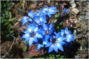 In Spring the trekking season
commences in moderate altitudes. Above 3000 metres, spectacular
rhododendron forests bloom. It is also the perfect time for a rafting
tour. In Paro, one of the largest monastic festivals, Paro tshechu,
takes place. In Spring the trekking season
commences in moderate altitudes. Above 3000 metres, spectacular
rhododendron forests bloom. It is also the perfect time for a rafting
tour. In Paro, one of the largest monastic festivals, Paro tshechu,
takes place.
The temperature is pleasantly mild even up to the Alp
regions. Rain comes only in May as the harbinger of the approaching
monsoon. The Summer brings with it the monsoon, but this should not
deter travelers. In the settled areas of the medium ranges of Central
and Western Bhutan pleasant summer temperatures without heat or humidity
can be found. Rain falls for short periods daily but is manageable with
adequate planning and equipment. Treks in high mountain areas, e.g. the
Snowman Trek, are characterized by mild temperatures, verdant green
meadows, and pastures of Blue Poppies and Edelweiss. Nomads tending
their yaks in the high Alps are a common sight. Autumn is the
traditional high season in Bhutan. September und October have the
highest number of tshechus (monastic festivals). Trekkers particularly
enjoy the clear view of the mountains in October and the low rainfall.
Rice harvest means a picturesque landscape remarkable terraces and
changing colour. Temperatures and vegetation in the altitudes
between 200 and 300 metres are comparable to the moderate climate of
middle Europe. The tree line lies just under 4000 metres. During winter
there is little precipitation. Snow falls rarely below 2500 metres.
� | 


